Ground Penetrating Radar (GPR) Techniques and Applications
Harry M. Jol
University of Wisconsin, Eau Claire
Department of Geography
105 Garfield Avenue
Eau Claire, WI 54702-4004

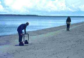 Ground Penetrating Radar (GPR) set up on a coastal spit. The GPR antennae are to the left in this photo with a wire
connecting the antennae to a laptop computer (on right). The GPR system is being used to obtain a "image" of the
subsurface which may be displayed on the computer in real-time.
Ground Penetrating Radar (GPR) set up on a coastal spit. The GPR antennae are to the left in this photo with a wire
connecting the antennae to a laptop computer (on right). The GPR system is being used to obtain a "image" of the
subsurface which may be displayed on the computer in real-time.
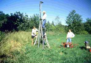
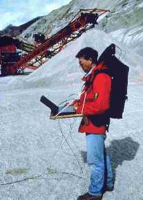 GPR and backpack operation for more remote locations. Setup includes
portable computer linked to the console, which are both powered by
12-volt batteries. Console is linked to antennae via fiber-optic
cables.
GPR and backpack operation for more remote locations. Setup includes
portable computer linked to the console, which are both powered by
12-volt batteries. Console is linked to antennae via fiber-optic
cables.
 GPR and wheelbarrow operation for level coastal environments. Setup
includes portable computer linked to the console and antennae, both
are powered by 12-volt batteries.
GPR and wheelbarrow operation for level coastal environments. Setup
includes portable computer linked to the console and antennae, both
are powered by 12-volt batteries.
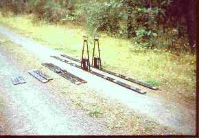 Four different antennae frequencies used in coastal research, from
left to right they are 200, 100, 50, and 25 MHz.
Four different antennae frequencies used in coastal research, from
left to right they are 200, 100, 50, and 25 MHz.
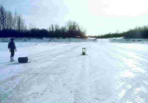 GPR bottom and sub-surface profiling using ice as a platform.
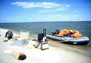
 GPR bottom and sub-surface profiling using a boat as a platform for
the antennae.
GPR bottom and sub-surface profiling using a boat as a platform for
the antennae.
 Robust and portable GPR systems allow access to remote locations via
Zodiac boats (northern shore of Lake Athabasca, Canada).
Robust and portable GPR systems allow access to remote locations via
Zodiac boats (northern shore of Lake Athabasca, Canada).
 Vibracoring coastal environments to confirm GPR profiling patterns.
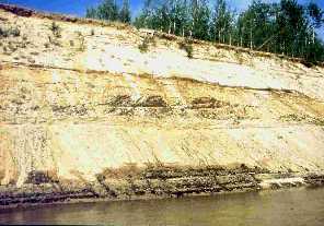 Outcrop of the Late Pleistocene Athabasca River braided delta plain
at Embarrass airfield, in northern Alberta, Canada.
Outcrop of the Late Pleistocene Athabasca River braided delta plain
at Embarrass airfield, in northern Alberta, Canada.
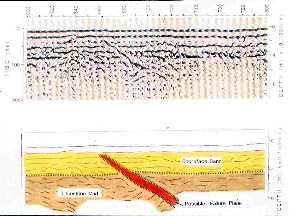
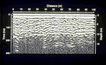 GPR profile of the Late Pleistocene Athabasca River braided delta plain
at Embarrass airfield, in northern Alberta, Canada. Black lines in the
profile indicate signals return to the receiver. The top most line is the direct travel
of the radar signal through the air to the receiver.
The second line indicates the direct surface return. Additional lines
(referred to as reflectors) indicate the structure of the subsurface.
GPR profile of the Late Pleistocene Athabasca River braided delta plain
at Embarrass airfield, in northern Alberta, Canada. Black lines in the
profile indicate signals return to the receiver. The top most line is the direct travel
of the radar signal through the air to the receiver.
The second line indicates the direct surface return. Additional lines
(referred to as reflectors) indicate the structure of the subsurface.
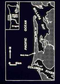 Location map showing Long Beach, Washington (USA). Long Beach is
within the Columbia River Littoral Cell, which extends from
Tillamook Head, OR north to Point Grenville, WA.
Location map showing Long Beach, Washington (USA). Long Beach is
within the Columbia River Littoral Cell, which extends from
Tillamook Head, OR north to Point Grenville, WA.
 Looking north along the Long Beach Peninsula. Note waves breaking
and reforming several hundred meters offshore.
Looking north along the Long Beach Peninsula. Note waves breaking
and reforming several hundred meters offshore.
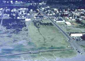 Aerial view of the Long Beach, WA study area. This shoreline has a
reflective beach with mean wave heights of over 2 meters.
Aerial view of the Long Beach, WA study area. This shoreline has a
reflective beach with mean wave heights of over 2 meters.
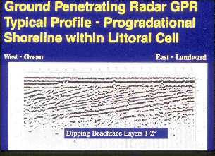 GPR profile of a progradational, wave-influenced, shoreline at a
study site within the Columbia River Littoral Cell.
GPR profile of a progradational, wave-influenced, shoreline at a
study site within the Columbia River Littoral Cell.
 Photo of the Panther Member near Helper, Utah. This has been interpreted
as a progradational, wave-influenced, shoreline.
Photo of the Panther Member near Helper, Utah. This has been interpreted
as a progradational, wave-influenced, shoreline.
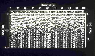 GPR profile of the Panther Member showing a progradational, wave-influenced,
shoreline (near Helper, Utah).
GPR profile of the Panther Member showing a progradational, wave-influenced,
shoreline (near Helper, Utah).
 Photo showing escarpment of the Slave River Valley, Northwest Territories, Canada.
 GPR profile showing the Early Holocene wave-influenced delta deposits
exhibiting possible postdepositional slumping.
GPR profile showing the Early Holocene wave-influenced delta deposits
exhibiting possible postdepositional slumping.
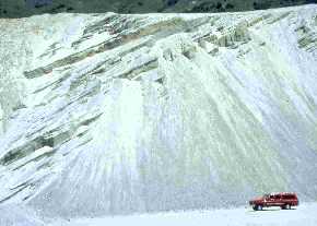 Photo of the Brigham Fan-Foreset Delta, located near Brigham City, Utah.
It was formed during the Prove Level of Lake Bonneville.
Photo of the Brigham Fan-Foreset Delta, located near Brigham City, Utah.
It was formed during the Prove Level of Lake Bonneville.
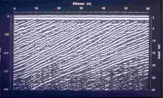 GPR profile of the Brigham Fan-Foreset Delta. Note the steeply
dipping reflection patterns from the GPR trace.
GPR profile of the Brigham Fan-Foreset Delta. Note the steeply
dipping reflection patterns from the GPR trace.
References
Jol, H.M., D.G. Smith, and R. Meyers. 1996. Digital ground penetrating radar (GPR): An improved and very effective geophysical tool
for studying modern coastal barriers. Journal of Coastal Research 12:960-968.
Meyers, R., D.G. Smith, H.M. Jol, and C.R. Peterson. 1996. Evidence for eight great earthquake-subsidence events detected with
ground penetrating radar, Willapa Barrier, Washington. Geological Society of America Geology 24:99-102.
Return to the Table of Contents